Observations
JMA operates an array of observation networks to monitor weather, climate and the environment around the clock on a nationwide scale.
Details Weather Observation , Observation System Operation
Surface Observation
Surface observation is carried out at about 1,300 stations using automatic observation equipment collectively known as the Automated Meteorological Data Acquisition System (AMeDAS). Stations are laid out at average intervals of 17 km throughout the country.
Observation at manned stations covers weather, wind direction/speed, amount of precipitation, type and base height of cloud, visibility, air temperature, humidity and atmospheric pressure. Data other than those relating to weather, visibility and cloud-related elements are automatically sent every ten seconds from manned stations and some unmanned stations, and every ten minutes from the remaining unmanned stations, of which about 700 observe four elements (precipitation, air temperature, wind direction/speed and humidity) and about 300 observe precipitation. In addition to these elements, snow depth is also observed at stations in areas of heavy snowfall. All observational data are transmitted to JMA Headquarters via telecommunication lines.
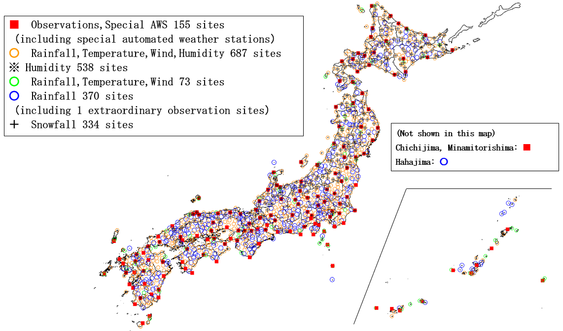
AMeDAS observation network (as of 1 April 2026)
Details Surface Observation , AMeDAS
Radar Observation
JMA operates a network of 20 C-band Doppler weather radars across Japan to observe the distribution of rainfall intensity and wind in terms of radial velocity. Precipitation Nowcasts generated every five minutes by merging all radar data are used both for weather monitoring and for obtaining initial values to be used in very short-range forecasts.
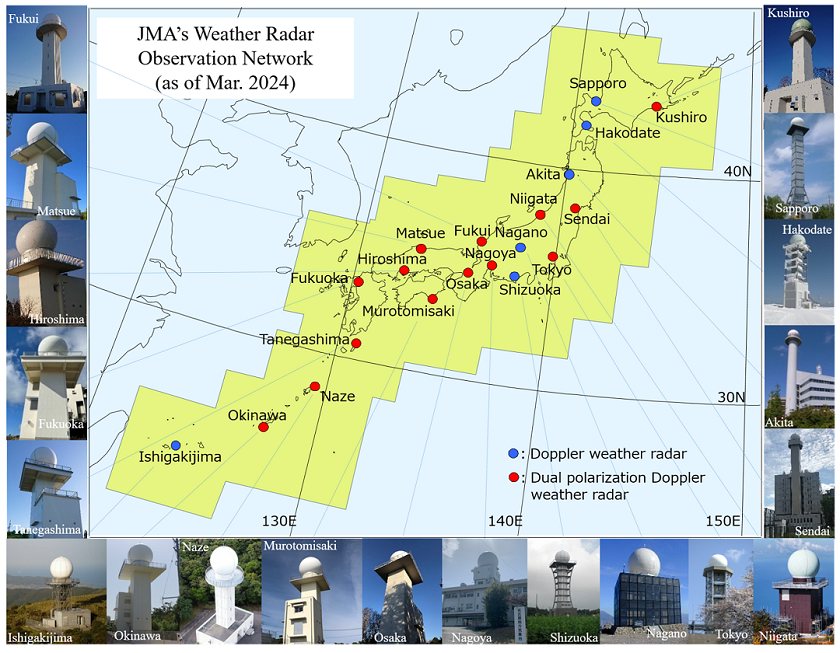
JMA Radar Observation Network (as of July 2025)
Details Weather Radar
Upper-air Observation
Upper-air observation is performed through two different networks: the radiosonde observation network (16 stations) and the wind profiler observation network (33 stations).
The radiosonde (a balloon-borne instrument platform with a radio-transmitting device) covers the upper air up to a maximum of 30 km from the surface, measuring temperature, pressure, humidity and wind.
Radiosonde observation is carried out twice a day at 0000 and 1200 UTC, and JMA's research vessel occasionally performs such observation in the western North Pacific and the seas adjacent to Japan.
The wind profiler — a ground-based multiple-beam Doppler radar unit — covers a range up to a maximum of 12 km from the surface and automatically measures wind every ten minutes. The observed data are collected at JMA Headquarters on a real-time basis.
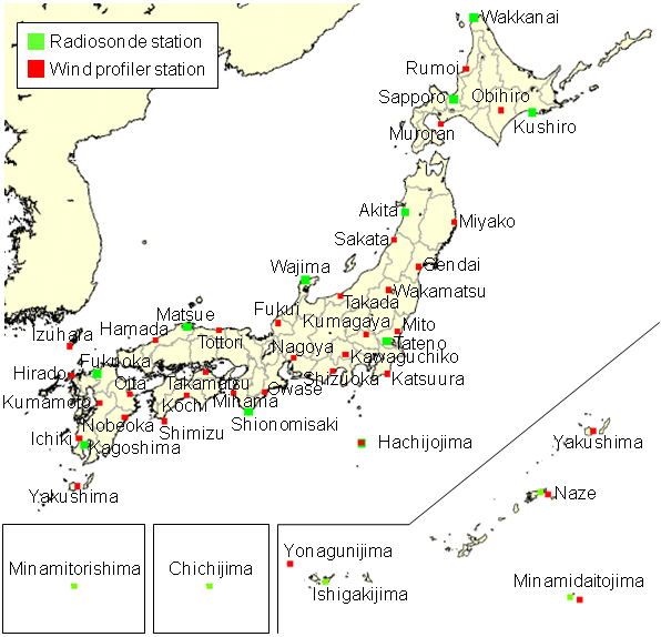
JMA Upper-air Observation
Details Radiosondes , Wind Profilers
Satellite-based Observation
In 1977, Japan launched the first geostationary meteorological satellite (GMS) into geostationary orbit (about 36,000 km above the equator at a longitude of 140 degrees east) mainly to cover the western Pacific and East Asia as part of a space-based component of the Global Observing System (GOS) under the WMO World Weather Watch (WWW) programme. Since then, continuous efforts have been made to maintain and enhance the observational capabilities of meteorological satellites.
Satellite observation provides a wealth of information, including data on cloud height and distribution, upper-air wind, and sea surface temperature distribution. The observational data received from the spacecraft allow JMA and other National Meteorological and Hydrological Services (NMHSs) to continuously monitor significant meteorological phenomena such as typhoons, fronts and low-pressure systems. The data are also directly assimilated into the numerical weather prediction system, which in turn contributes to the timely issuance of disaster prevention information and weather forecasts from JMA and NMHSs.
The Himawari-8 satellite launched in 2014 is now in operation, performing observation every 10 minutes with three visible, three near-infrared and ten infrared bands. Himawari-9 has the same imaging function as Himawari-8, and was launched in 2016 as a backup and successor satellite. JMA uses information from the Himawari series of satellites and from various low Earth orbit satellites in its operations. Data from these satellites are indispensable for observing typhoons, monitoring global and marine environments and producing initial fields for numerical weather prediction.
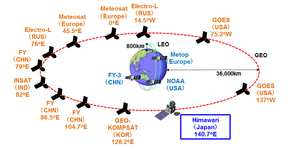
Current space-based component of the Global Observation System
Details Meteorological Satellites
Lightning Monitoring
The lightning monitoring system pinpoints the time and location of lightning occurrences by detecting radio waves caused by lightning flashes. Data from individual detectors located at 30 airports are gathered and processed by the Data Processing Center at JMA. The results are delivered immediately to airlines for purposes such as securing ground operations at airports and managing aircraft in Japan's airspace.
Geomagnetic Observation
JMA's Kakioka Magnetic Observatory carries out geomagnetic and geoelectric observation. Routine geomagnetic observation in Japan was begun in Akasaka (Tokyo) in 1883 during the First International Polar Year (1882 – 1883). The observatory was moved to Kakioka (Ibaraki Prefecture) in January 1913, and observation has continued there for more than 100 years. Observation is also implemented at two branches in Memambetsu (since 1949) and Kanoya (since 1948) and at one unmanned site in Chichijima (since 1970).
In 1973, the Kakioka Magnetic Observatory was designated as one of four such facilities worldwide to be involved in the calculation of the Dst index, which represents the strength of the equatorial ring current encircling the earth. The Kakioka, Memambetsu and Kanoya observatories became members of the International Real-time Magnetic Observatory Network (INTERMAGNET) in 1992, 1994 and 2002, respectively. JMA's observatories play an important role in geomagnetic observation in the Asian-Pacific region.
Data from the observatories are utilized for solar-terrestrial environment monitoring and space weather forecasting, and also for studies on the prediction of volcanic eruptions.
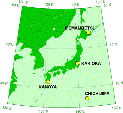
JMA Geomagnetic Observation sites
Utilization of Observational Data Obtained Through Relevant Authorities
In addition to the aforementioned comprehensive observation network operated by JMA itself, the Agency also actively exchanges meteorological observational data with relevant central governmental and local authorities on a real-time basis. The integrated usage of such rain-gauge and radar data with those of JMA plays a vital role in the forecasting of torrential rain.