Surface Observation
Overview
A total of approximately 60 manned weather stations and 90 unmanned Special Automated Weather Stations are run by the Japan Meteorological Agency (JMA), including Local Meteorological Offices. Located nationwide, these stations routinely observe various meteorological elements such as surface pressure, temperature, humidity, wind direction/speed, precipitation, snow depth, snowfall, sunshine duration, solar radiation, visibility, cloud and weather phenomena.
Meteorological data are essentially recorded via automatic surface observation, while cloud conditions, visibility and weather phenomena are observed by staff at Regional Headquarters in Tokyo and Osaka.
The observation data recorded are used for the issuance of weather forecasts, weather warnings/advisories and related information, and are also utilized in a range of operational and research fields including those related to climate change and socio-economic activities.
Surface Observation Sites
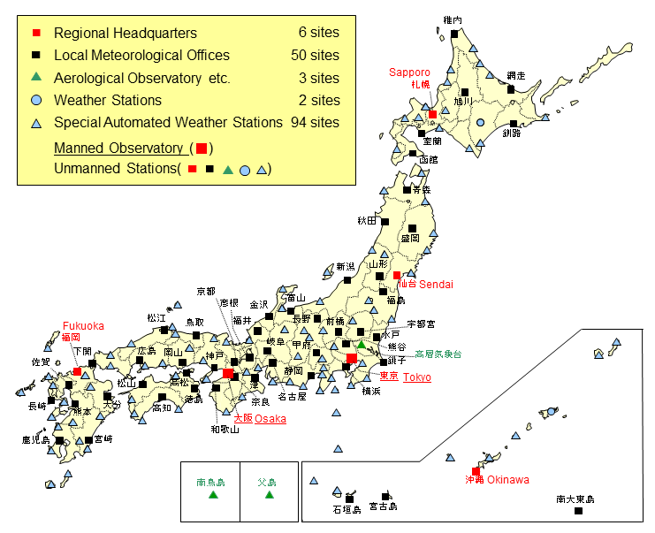
Surface observation network (As of 26 March 2024)
Surface Weather Observing System
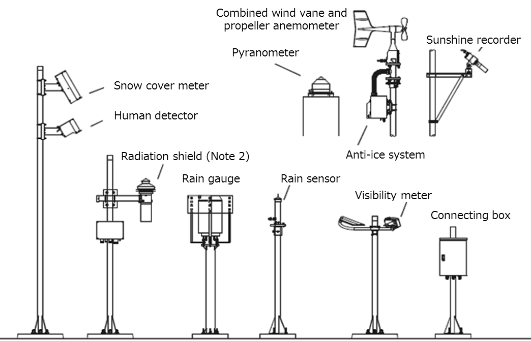
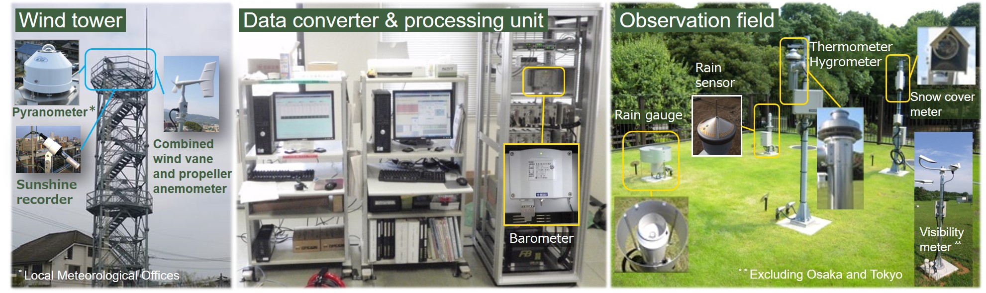
Surface weather observing system equipment at Local Meteorological Offices and Special Automated Weather Stations is used to observe weather-related elements such as surface pressure, temperature, humidity, wind direction/speed, precipitation, snow depth and sunshine duration. The system's elements are mostly installed in observation fields (Note 1) or on observatory rooftops, while their barometers and signal converters are located in indoor observation spaces.
Surface weather observing system equipment includes electrical thermometers, electrical hygrometers, tipping bucket rain gauges, electronic barometers, propeller anemometers, electrical global pyranometers, rotating mirror sunshine recorders (measuring how long the ground surface is subjected to direct solar radiation), laser-based snow depth gauges and visibility meters.
Note 1) Observation fields: Spaces where observing instruments are placed to secure a stable environment free from the effects of surrounding artificial objects. Observation fields are usually covered with grass to mitigate heat influence from the ground.
Surface weather observing system
Note 2) Double circular cylinders: Equipment in which thermometers and hygrometers are embedded. Insulating material is installed between cylinders, and artificial ventilation is provided to eliminate the influence of solar radiation. An extra shield plate is also attached to the bottom of the cylinders to prevent any effect from solar radiation absorbed by the ground.
Observation equipment
| Observation element | Observation equipment | Number of stations including AWS** | Observation spot | |
|---|---|---|---|---|
| Temperature |
|
|
915 | Observation field |
| Rain |
|
|
1285 | |
| Snow |
|
|
333 | |
| Wind |
|
|
915 | Wind tower or rooftop |
| Sunshine |
|
|
155 | |
| Pressure |
|
|
155 | Observation room |
| Humidity |
|
|
588 | Observation Field |
| Presence and intensity of precipitation |
|
|
155 | |
| Solar radiation |
|
|
48 | |
| Visibility, weather and atmospheric phenomena |
|
|
2 | |
| Visibility and weather |
|
|
153 | |
*Observation dates and times are recorded.
**As of 1 April 2024
Automatic identification of meteorological phenomena
Meteorological phenomena are identified automatically from satellite, surface observation equipment such as visibility meters and electrical thermometers.
-
Sunny vs. cloudy conditions
High-resolution Cloud Analysis Information (HCAI) and data on the potential for sunshine in the hour before from automatic weather observation are referenced to determine sunny and cloudy conditions.
In the absence of sufficient HCAI, only data on the potential for sunshine in the hour before are referenced. Only HCAI is referenced at nighttime, as there are no sunshine observations.
In the absence of sufficient HCAI and sunshine duration data due to maintenance or automatic satellite sun avoidance, it may not be possible to ascertain current weather conditions.
-
Rain vs. sleet vs. snow
Temperature and humidity data are referenced in automatic observation using rain sensors to determine whether precipitation is rain, sleet or snow. If precipitation is not observed or temperature/humidity data are insufficient, the distinction cannot be made.
| Local Meteorological Offices etc.(56) | Hokkaido region(8) | Sapporo, Hakodate, Asahikawa, Muroran, Kushiro, Obihiro, Abashiri, Wakkanai |
| Tohoku region(6) | Sendai, Aomori, Morioka, Akita, Yamagata, Fukushima | |
| Kanto Koshin region(8) | Mito, Utsunomiya, Maebashi, Kumagai, Saiko, Yokohama, Kofu, Nagano | |
| Tokai region(4) | Nagoya, Gifu, Shizuoka, Tsu | |
| Hokuriku region(4) | Niigata, Toyama, Kanazawa, Fukui | |
| Kinki region(5) | Hikone, Kyoto, Kobe, Nara, Wakayama | |
| Chugoku region(4) | Hiroshima, Tottori, Matsue, Okayama | |
| Shikoku region(4) | Takamatsu, Tokushima, Matsuyama, Kochi | |
| Northern Kyushu region(6) | Fukuoka, Shimonoseki, Saga, Nagasaki, Kumamoto, Oita | |
| Southern Kyushu region(3) | Kagoshima, Miyazaki, Naze | |
| Okinawa region(4) | Naha(Okinawa), Miyakojima, Ishigakijima, Minamidaitojima | |
| Special Automated Weather Staions Offices (93) | Hokkaido region(14) | Esashi Kitami, Haboro, Rumoi, Iwamizawa, Otaru, Kutchan, Suttsu, Omu, Monbetsu, Nemuro, Hiroo, Tomakomai, Urakawa, Esashi |
| Tohoku region(11) | Mutsu, Fukaura, Hachinohe, Miyako, Ofunato, Ishinomaki, Sakata, Shinjo, Wakamatsu, Shirakawa, Onahama | |
| Kanto Koshin region(13) | Nikko, Chichibu, Oshima, Miyakejima, Hachijojima, Chiba, Katsuura, Tateyama, Karuizawa, Matsumoto, Suwa, Iida, Lake Kawaguchi | |
| Tokai region(10) | Mishima, Ajiro, Hamamatsu, Omaezaki, Irozaki, Irago, Takayama, Yokkaichi, Ueno, Owase | |
| Hokuriku region(5) | Aikawa, Takada, Fushiki, Wajima, Tsuruga | |
| Kinki region(5) | Maizuru, Toyooka, Himeji, Sumoto, Shionomisaki | |
| Chugoku region(7) | Tsuyama, Fukuyama, Kure, Saigo, Hamada, Sakai, Yonago | |
| Shikoku region(5) | Tadotsu, Uwajima, Cape Muroto, Sukumo, Shimizu | |
| Northern Kyushu region(11) | Hagi, Yamaguchi, Iizuka, Hita, Izuhara, Hirado, Sasebo, Mt. Unzen, Fukue, Hitoyoshi, Ushibuka | |
| Southern Kyushu region(8) | Nobeoka, Miyakonojo, Aburatsu, Akune, Makurazaki, Tanegashima, Yakushima, Okinoerabu | |
| Okinawa region(4) | Nago, Kumejima, Yonagunijima, Nishiomotejima | |
| Aerological Observatory etc. (2) | Tateno, Chichijima | |
-
Lightning
Lightning is automatically identified at observation stations using LIDEN (the LIghting DEtecthion Network system) and data on convective cells from meteorological weather radar within a radius of 40 km from automatic weather observation stations. If LIDEN or meteorological radar data are insufficient, lightning is not identified.
| Local Meteorological Offices etc.(56) | Hokkaido region(8) | Sapporo, Hakodate, Asahikawa, Muroran, Kushiro, Obihiro, Abashiri, Wakkanai |
| Tohoku region(6) | Sendai, Aomori, Morioka, Akita, Yamagata, Fukushima | |
| Kanto Koshin region(8) | Mito, Utsunomiya, Maebashi, Kumagai, Saiko, Yokohama, Kofu, Nagano | |
| Tokai region(4) | Nagoya, Gifu, Shizuoka, Tsu | |
| Hokuriku region(4) | Niigata, Toyama, Kanazawa, Fukui | |
| Kinki region(5) | Hikone, Kyoto, Kobe, Nara, Wakayama | |
| Chugoku region(4) | Hiroshima, Tottori, Matsue, Okayama | |
| Shikoku region(4) | Takamatsu, Tokushima, Matsuyama, Kochi | |
| Northern Kyushu region(6) | Fukuoka, Shimonoseki, Saga, Nagasaki, Kumamoto, Oita | |
| Southern Kyushu region(3) | Kagoshima, Miyazaki, Naze | |
| Okinawa region(4) | Naha(Okinawa), Miyakojima, Ishigakijima, Minamidaitojima |