Japanese
Home > Services > Forecasting Services > High-resolution Precipitation Nowcasts

High-resolution Precipitation Nowcasts

What are High-resolution Precipitation Nowcasts?

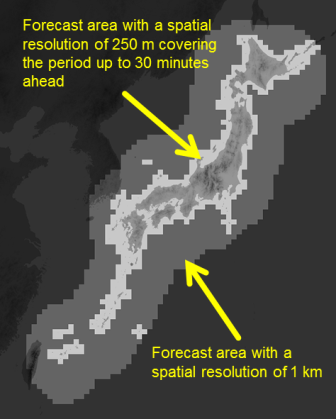
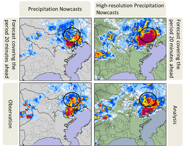
  High-resolution Precipitation Nowcasts (HRPNs) provide short-range precipitation intensity predictions with a spatial resolution of 250 m. They are derived from weather radar data and other types of meteorological information.
  The Japan Meteorological Agency (JMA) observes precipitation distribution all over Japan using 20 Doppler radars. Between April 2012 and March 2014, the previous radars were replaced with units featuring a 250-m radial resolution (offering twice as much detail as before) for improved observation of local downpours.
  HRPN derivation also involves the use of raingauge data, wind profiler data, radiosonde observation data and other radar observation data (such as those from X-band radars (XRAIN) managed by Japan's Ministry of Land, Infrastructure, Transport and Tourism (MLIT)) in addition to weather radar data. The data are first analyzed to create a three-dimensional structure of the precipitation area, and forecasts of precipitation intensity distribution with a spatial resolution of 250 m covering the period up to 30 minutes ahead are then made.

Resolution of High-resolution Precipitation Nowcasts

  Processing and disseminating high-resolution (i.e., large-volume) observation data for high-resolution forecasts generally takes longer than for the low-resolution data used in low-resolution forecasts. To mitigate the burden involved in the timely processing of these larger-volume data and enable prompt Nowcast issuance, JMA provides the new HRPNs with a high spatial resolution of 250 m for land and coastal regions of Japan, but the resolution is limited to 1 km for more distant sea areas. The coverage of both is up to 30 minutes ahead.
Resolution
Figure: For light-gray areas, forecasts covering the period up to 30 minutes ahead at a spatial resolution of 250 m are provided. For dark-gray areas, the resolution is 1 km. For both, forecasts covering the period from 35 to 60 minutes ahead are made with a spatial resolution of 1 km. For gunmetal-gray areas, no forecasts are provided.


Example involving High-resolution Precipitation Nowcasts

  The following figure shows images from a heavy rain event that occurred on 29 June 2014. HRPNs successfully forecast areas of strong rain (as highlighted by the black circles) more accurately than existing Precipitation Nowcasts.
Example
Figure: Upper left: existing Precipitation Nowcasts (initial time: 16:00 JST, 29 June 2014; forecast coverage period: 20 minutes ahead)
Upper right: HRPN (initial time and forecast coverage period as per upper left)
Lower left: observation values of existing Precipitation Nowcasts (16:20 JST, 29 June 2014)
Lower right: analyzed values of the HRPN (time as per lower left)

Techniques of Precipitation Analysis and Prediction

  Techniques of Precipitation Analysis and Prediction developed for HRPNs (PDF, 1.04 MB)