| Located in one of the most active seismic and volcanic zones in the world, Japan is frequently affected by earthquakes and volcanic disasters. JMA operationally monitors seismic and volcanic activity throughout the country and issues relevant warnings and information to mitigate damage caused by disasters related to earthquakes, tsunamis and volcanic eruptions. |  Earthquake distribution around Japan (1960-2011) |
|
To monitor earthquakes, JMA operates an earthquake observation network comprised of about 200 seismographs and 600 seismic intensity meters.
It also collects data from over 3,600 seismic intensity meters managed by local governments and the National Research Institute for Earth Science and Disaster Resilience(NIED).
The data collected are input to the Earthquake Phenomena Observation System (EPOS) at the headquarters in Tokyo and the Osaka District Meteorological Observatory on a real-time basis.
When an earthquake occurs, JMA immediately issues information on its hypocenter, magnitude and observed seismic intensity. If the seismic intensity is 3 or greater, the Agency issues a Seismic Intensity Information report within one and a half minutes. The information is provided to disaster prevention authorities via dedicated lines, and reaches the public through local governments and the media. This information also plays a vital role as a trigger for the initiation of rescue and relief operations related to earthquake disasters. |  Sites of seismic intensity meters (as of January 5, 2012) |
|
Seismic intensity describes the scale of the ground motion at a particular location.
It varies with the distance from the epicenter and the surface geology at each point.
JMA's seismic intensity scale has 10 degrees (0 (imperceptible), 1, 2, 3, 4, 5 lower, 5 upper, 6 lower, 6 upper, 7).
The seisimic intensity is measured with a seisimic intensity meter. "Tables explaining the JMA Seismic Intensity Scale" describes the situations and damage which may be caused by seismic motion of each seismic intensity. - Summary of Tables explaining the JMA Seismic Intensity Scale (PDF 197 KB) |
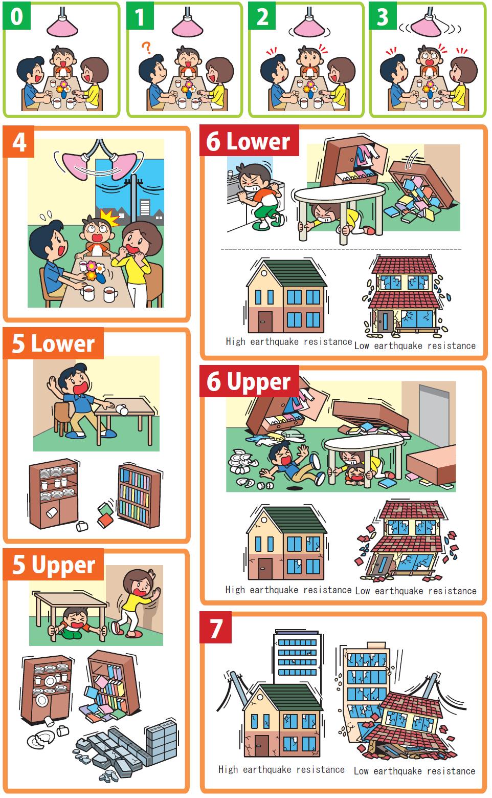 Seismic Intensity |
|
The Earthquake Early Warning system provides advance announcement of the estimated seismic intensity and expected arrival time of principal motion when an earthquake occurs.
These estimations are based on prompt analysis of the quake's focus and magnitude using waveform data obtained from seismographs near the epicenter.
The Earthquake Early Warning system is aimed at mitigating earthquake-related damage by allowing countermeasures such as promptly slowing down trains, controlling elevators to avoid danger and enabling people to quickly protect themselves in various environments such as factories, offices, houses and near cliffs. ---> Earthquake Early Warnings |
 |
|
To reduce and mitigate catastrophic losses caused by tsunamis, immediate provision of tsunami information for coastal regions is essential.
When an earthquake occurs, JMA estimates the possibility of tsunami generation from seismic observation data.
If a damaging tsunami is expected in coastal regions,
JMA issues a Tsunami Warning/Advisory for each region within around two to three minutes of the quake.
If tsunamis are generated by seismic events far from Japan, the Agency engages in coordinated action with the Pacific Tsunami Warning Center (PTWC) in Hawaii and issues warnings for long-propagating tsunamis.
---> Tsunami Warning/Advisory ---> Map of Tsunami Forecast Regions (PDF Image) |
 Time sequence for issuance of information on tsunamis and earthquakes |
|
Along the Nankai Trough, megathrust earthquakes with a magnitude 8 or more occur repeatedly. These are generally referred to as Nankai Trough Earthquakes. Although Nankai Trough Earthquakes occurred with a roughly 100 - 150 year cycle, they have various repetition intervals and source regions. They are difficult to accurately predict in terms of timing, location and scale.
Among previous megathrust earthquakes in the trough, the Ansei Tokai Earthquake of 1854 and the Showa Tonankai Earthquake of 1944 (occurring in the eastern part of the trough) were followed 32 hours later by the Ansei Nankai Earthquake of 1854 and 2 years later by the Showa Nankai Earthquake of 1946 (occurring in the western part of the trough), respectively. Accordingly, the occurrence of a megathrust earthquake along the trough may be associated with elevated potential for a future occurrence elsewhere in the trough. In addition, numerous slow slips are observed in periods of normal activity on the plate boundary around the assumed source region of Nankai Trough earthquakes. These phenomena are seen as indicators of change in the coupling conditions of the boundary. A slow slip in an unusual region of the trough or an irregular occurrence mode (such as a high change rate) can also be considered to indicate elevated potential for a Nankai Trough earthquake. JMA has developed a local seismic and crustal deformation observation network in conjunction with related organizations to enable 24-hour monitoring. If anomalies are detected along the Nankai Trough or a large earthquake occurs in the region, JMA convenes the Nankai Trough Earthquake Assessment Committee for discussions on the expected potential for earthquake occurrence and issues Nankai Trough Earthquake Extra Information to the public via the JMA website and other channels such as TV and radio. An earthquake could occur in the Nankai Trough at any time without the opportunity for issuance of related information in advance. Accordingly, it is important to prepare for major earthquakes as part of daily life. It should be noted that the issuance of information indicating elevated potential for a Nankai Trough earthquake does not necessarily mean that one will actually strike. |
 Spatio-temporal distribution of the source area of Nankai Trough Earthquakes (Quoted from Long-term Evaluation of the Nankai Trough Earthquake (Second edition), Headquarters for Earthquake Research Promotion (partly modified)) |
|
JMA monitors seismicity and crustal deformation along the Nankai Trough around the clock. If anomalous phenomena are detected or the possibility of
an earthquake along the Nankai Trough is considered relatively high, Nankai Trough Earthquake Information is issued as outlined below.
|
 |
|
Nanaki Trough Earthquake Extra Information is issued with the title Nankai Trough Earthquake Extra Information (Megathrust Earthquake Alert) with appended keywords. Examples of keywords and disaster prevention measures are shown below.
|
 |
 |
| English | 中文(简体) | 中文(繁體) | 한국어 |
| Español | Português | Tiếng Việt | ภาษาไทย |
| Bahasa Indonesia | Tagalog | नेपाली भाषा | ភាសាខ្មែរ |
| မြန်မာ | Монгол хэл |
|
The Pacic Plate subducting beneath Japan forms the Japan Trench (off the coast of the Boso Peninsula to the east of Aomori Prefecture) and the
Chishima Trench (off the coast of Tokachi toward off the coast of Etorofu and eastward),where many large earthquakes have occurred in the past.A large earthquake which causes a massive tsunami and strong ground motions could well happen in the area in the future.
As multiple large earthquakes have occurred locally within clusters of a few days, there is a need for precaution both against initial large earthquakes and against following large ones. |
 Estimated seismic intensities and tsunami heights is based on data from the Central Disaster Mitigation Council, 2022. |
|
If a M7.0 or greater earthquake occurs in or around the probable source region of megaquakes along the Japan and Chishima Trenches, the possibility of
a large earthquake is considerd to be relatively high.
JMA issues Off the Coast of Hokkaido and Sanriku Subsequent Earthquake Advisory in such cases, even though probability based on actual worldwide records is only about 1/100. |
 |
 |
|
|
| English | 中文(简体) | 中文(繁體) | 한국어 |
| Español | Português | Tiếng Việt | ภาษาไทย |
| Bahasa Indonesia | Tagalog | नेपाली भाषा | ភាសាខ្មែរ |
| မြန်မာ | Монгол хэл |
|
In the eastern Izu district, seismic swarms related to magma activity have frequently occurred in the past.
Based on the data obtained from past activities, JMA evaluates the transition and prospect of further earth quakes in eastern Izu.
If anomalous crustal deformation caused by magma rising is detected and active seismicity is expected, JMA issues information on the maximum possible magnitude and Seismic Intensity of the largest earthquake, the expected number of earthquakes with a Seismic Intensity of 1 or greater, and the expected duration of the activity. |
 |
 |
 |
|
There are 111 active volcanoes in Japan; on average, a total of 15 volcanic events (including eruptions) occur every year, some of which seriously hinder human life.
To continuously monitor this volcanic activity, JMA deploys seismographs and related observation instruments in the vicinity of 50 volcanoes that are remarkably active.
Mobile observation teams are sent to other volcanoes for regular patrols.
When volcanic anomalies are detected, the Agency steps up its monitoring/observation activities and publishes volcanic information and regular bulletins.
In order to detect unusual volcanic phenomena and issue volcanic information appropriately, JMA operates Volcanic Observation and Warning Centers at JMA Headquarters and at the Sapporo, Sendai and Fukuoka Regional Headquarters of JMA, which integrate various types of observation data and monitor volcanic activity in their areas of responsibility. |
| JMA began issuing Volcanic Warnings and Volcanic Forecasts for each active volcano in Japan on Dec 1, 2007 to mitigate damage from volcanic activity. Volcanic Warnings are issued in relation to expected volcanic disasters, and specify the municipalities where people need to take action. Volcanic Forecasts are issued for less active volcanoes or those that become so. |
|
The Coordinating Committee for Prediction of Volcanic Eruption was established in 1974 under the Volcanic Eruption Prediction Plan.
The Committee is comprised of experts from related academic fields and organizations, and the secretariat is located at JMA.
The group periodically reviews volcanic activity in Japan and provides outlooks on volcanic eruptions when required.
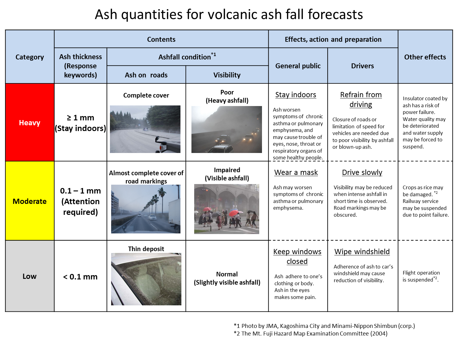
- Volcanic Warnings - What are Volcanic Warnings and Volcanic Alert Levels? - What is an Eruption Notice? - Volcanic Ash Fall Forecasts - Categories of ash fall amount and corresponding conditions/preparedness measures - Tokyo Volcanic Ash Advisory Center (VAAC) |
 Active volcanoes in Japan |