Himawari JDDS
Himawari-8/9 imagery and geophysical products are provided via the JMA Data Dissemination System (JDDS). Satellite imagery and products such as High-resolution Cloud Analysis Information (HCAI) are provided via the Himawari JDDS.
Data access without registration
The JPEG satellite imagery listed in Table 1 is freely available without the need for registration.
| Area Name | Time Interval |
| Full disk (FD) | Every 60 minutes |
| North Central | Every 30 minutes |
| Northwest | Every 30 minutes |
| Northeast | Every 30 minutes |
| Sout Central | Every 30 minutes |
| Southwest | Every 30 minutes |
| Southeast | Every 30 minutes |
| East Asia | Every 30 minutes |
| North Japan | Every 30 minutes |
| Southwest Japan | Every 30 minutes |
Data for National Meteorological and Hydrological Services
National Meteorological and Hydrological Services (NMHSs) can access the following satellite imagery and products via HTTPS after registration:
- High-resolution Cloud Analysis Information (HCAI)
- AMV-based Sea-surface Wind data (ASWinds)
- Satellite imagery in HRIT format
High-resolution Cloud Analysis Information (HCAI)
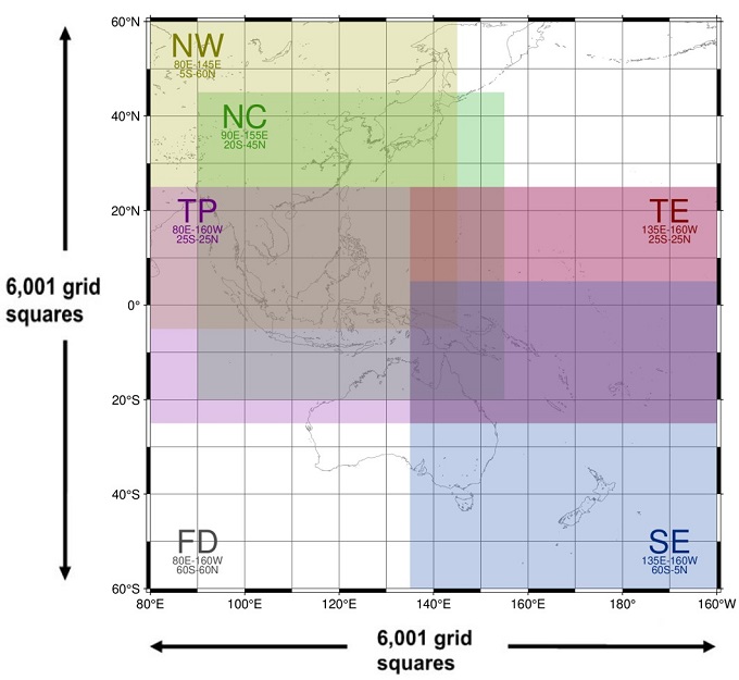
High-resolution Cloud Analysis Information consists of data on cloud mask (including dust mask), snow mask, cloud type, cloud top height and quality control. Each element has a spatial resolution of 0.02 degrees in both latitude and longitude, and is calculated using observational data from Himawari-8 or -9. The region of HCAI coverage is as detailed in Table 2 and Figure 1 below.
| Area Name | Latitude | Longititude | File size / 10 min. | Compressed file size / 10min. | |
| FD | Full Domain | 60N-60S | 80E-160W | 180 MB | 29.5 MB |
| NC | North Central | 45N-20S | 90E-155E | 50 MB | 10 MB |
| NW | Northwest | 60N-5S | 80E-145E | 50 MB | 10 MB |
| TP | Tropical | 25N-25S | 80E-160W | 75 MB | 15 MB |
| TE | Tropical East | 25N-25S | 135E-160W | 40 MB | 7.5 MB |
| SE | Southeast | 5N-60S | 135E-160W | 50 MB | 10 MB |
AMV-based Sea-surface Wind data (ASWinds)
AMV-based Sea-surface Wind data (ASWinds) is an ocean-surface wind product involving wind speed estimation from the strong correlation between low-level AMVs, which are assigned to the lower troposphere, and sea-surface winds around tropical cyclones. It provides valuable information on wind distribution around tropical cyclones over ocean areas, where observation data are particularly sparse, using low-level AMVs derived from Himawari-8 full-disk and target-area imagery. In combination with JMA’s HimawariRequest service for tropical cyclone observation, the ASWinds product derived from target-area observation is expected to significantly contribute to tropical cyclone monitoring. The AMV-based Sea-surface Wind data are shown in Table 3.
| Area Name | Latitude | Longitude | File size | Interval | Spatial resolution | |
| FD | Full Domain | 65N-65S | 80E-160W | 1 MB | 30 min | 0.25 deg |
| TG | Target Area | 1,000 km x 1,000 km | 200 KB | 10 min | 0.1 deg | |
Himawari-8/9 ASWinds were validated for areas around TCs occurring in 2016 based on comparison with ASCAT winds. The root mean square difference of the wind speed was 1.4 to 1.7 m/s. The following document provides details of product validation and other information:
Although the accuracy of ASWinds data around tropical cyclones has been verified, it is important to understand that their reliability for other regions, such as around extratropical cyclones, remains unverified.Satellite imagery in HRIT format
JMA provides Himawari-8/9 data in the format prescribed by HRIT regulations. These data are intended to support users of the previous operational MTSAT series as an interim measure until preparations are complete for the reception of Himawari-8/9 data via HimawariCloud or HimawariCast. The details of Himawari-8/9 imagery in HRIT format are shown in Table 4.
| Format | Product area | Interval | Notes |
| HRIT | Full disk | Every 30 minutes | Bands: 5 (VIS: 1; IR: 4) Spatial resolution: VIS: 1 km; IR: 4 km Northern/southern disk division Archived in tar and compressed gzip format |
Terms and conditions
JMA provides Himawari JDDS accounts to National Meteorological and Hydrological Services (NMHSs). Before using the service, users must submit fully completed and signed registration forms in scanned PDF format.
Once registration is complete, JMA will provide a user ID, password and dedicated URL. Users access data via an HTTPS client such as a Web browser or Wget.
Extremely heavy access impairing the download activities of other users may be recognized as a cyber-attack. Accordingly, users are asked to comply with the guidelines provided below to avoid having access terminated without notice.
- Refrain from downloading the same files repeatedly except in the event of a failed download.
- Refrain from downloading the same files with a different client.
Contact details for issues and inquiries:
- Satellite Program Division, Japan Meteorological Agency
- E-mail: metsat AT met.kishou.go.jp
Satellite Program Division, Japan Meteorological Agency
E-mail: metsat AT met.kishou.go.jp