Introduction of MTSAT
MTSAT-1R and MTSAT-2 meteorological services ended on 23 December, 2015 and 10 March, 2017, respectively.
MTSAT series
Outline
The Multi-functional Transport Satellite (MTSAT) series fulfills a meteorological function for the Japan Meteorological Agency and an aviation control function for the Civil Aviation Bureau (CAB) of the Ministry of Land, Infrastructure and Transport(MLIT). The MTSAT series succeeds the Geostationary Meteorological Satellite (GMS) series as the next generation of satellites covering East Asia and the Western Pacific.
Meteorological Mission
The most valuable feature of geostationary meteorological satellites is that they can globally observe atmospheric phenomena uniformly, including overlying areas in sea, desert and mountain regions where weather observation is difficult.
As an important part of the World Meteorological Organization's activities, the World Weather Watch Programme is supported by multiple geostationary and polar-orbiting meteorological satellites that comprise the space-based part of an observation network for severe weather, typhoons, hurricanes and cyclones around the earth.
To improve meteorological services over a wide field of activity (such as weather forecasts, natural-disaster countermeasures and securing safe transportation), the MTSAT series replaced the GMS series that had been in operation since 1977. It has taken over the role of the GMS series, covering East Asia and the Western Pacific region.
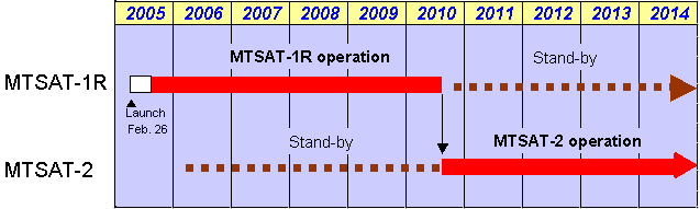
The operation plan of the MTSAT-1R and MTSAT-2 (meteorological service)
Observation
MTSAT provides information to more than 30 countries and territories in the region, including 1) imagery for monitoring the distribution/motion of clouds, 2) sea surface temperatures and 3) distribution of water vapor.
The MTSAT series provides imagery for the Northern Hemisphere every 30 minutes in contrast to the previous hourly rate, enabling JMA to more closely monitor typhoon and cloud movement.
The MTSAT series carries a new imager with a new infrared channel (IR4) in addition to the four channels (VIS, IR1, IR2 and IR3) of the GMS-5.
MTSAT imagery is more effective than GMS-5 imagery in detecting low-level cloud/fog and estimating sea surface temperatures at night and has enhanced brightness levels, enabling a whole new level of image imagery.
By further computation of cloud imagery, data obtained by MTSAT's observations can be used to 1) in calculate wind data for numerical weather prediction, 2) make nephanalysis charts and 3) analyze the distribution of cloud amounts according to area.
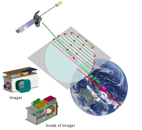
Imager - the "eye" on the sky -
The Imager scans the earth by moving an internal scan mirror in an east-west and north-south direction. The light reflected by the mirror is converted into a beam and channeled through a system of lenses and filters, and is separated into one visible and four infrared channels.
The beam intensities are converted to electric signals by visible and infrared detectors, and these signals are transmitted to the Meteorological Satellite Center's Command and Data Acquisition Station (CDAS).
Basic Information
| Basic Information on MTSAT series | |
|---|---|
| Position | Geostationary orbit 35,800 km above the equator at around 140 degrees east longitude or around 145 degrees east longitude |
| Attitude control | Three-axis stabilization
(system to control roll, pitch and yaw using thrusters or momentum wheels) |
| Designed lifetime | 5 years for each MTSAT of the meteorological function, 10 years for the aviation function |
Satellite Program Division, Japan Meteorological Agency
E-mail: metsat AT met.kishou.go.jp