On 24 May 2012, the Japan Meteorological Agency (JMA) announced that JMA will start operating the latest generation of the HITACHI supercomputer system from 5 June 2012, aiming to improve its meteorological information for disaster risk reduction and aviation service. The new system, HITACHI SR16000/M1, is about 30 times faster than its predecessor, HITACHI SR11000, and is with the ability to make more than 800 trillion floating-point calculations per second.
Comparison of Specification
|
Old |
New |
| Model |
HITACHI SR11000/K1
HITACHI SR11000/J1 |
HITACHI SR16000/M1 |
| Theoretical Peak Performance |
27.5 TFlops* |
847 TFlops |
| Capacity of Main Memory |
13.1 TByte |
108 TByte (including control) |
| Capacity of Magnetic Disk |
18.6 TByte |
348 TByte |
* TFlops: capability to perform one trillion floating-point calculations per second
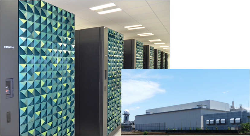
Left: The new supercomputer system to be used for JMA's weather and climate forecasting.
Right: New housing for the supercomputer system located in Tokyo.
The new system will allow JMA to run more sophisticated models of the atmosphere and oceans, leading to better accuracy and precision in from very short-range to long-range forecasting. In two months, JMA will operationally run the Local Forecast Model (LFM) with a horizontal resolution of 2 km, currently in test operation, over East Japan every three hours to make nine-hour forecasts, particularly aiming at timely service of fine-grid forecast to support aeronautical operation especially in the vicinity of Tokyo International (Haneda) airport. By improving its horizontal resolution to 2 km, more detailed terrain can be resolved in the model, thereby improving accuracy of prediction of wind, temperature and precipitation mainly related to local topography. In addition, in one year, the LFM will be modified to cover entire Japan and to run every hour for more sophisticated meteorological forecasts to further support disaster risk reduction and safer flights over the nation.
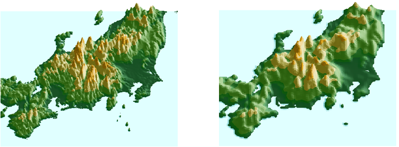
Terrain of the central region of the Main Island of Japan used for the LFM (left, 2-km horizontal resolution) and for the MSM (right, 5-km horizontal resolution)
On 29 July 2011, the front stayed from the Korean Peninsula through Hokuriku region to the east side of Kanto region, and continuous inflow of very humid air toward the front caused a record heavy rainfall in Niigata and Fukushima Prefectures. The LFM with a horizontal resolution of 2 km predicted the intensity and area of precipitation better than the MSM with a horizontal resolution of 5 km as shown in below figures.
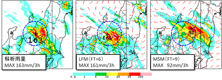
Three-hour rainfall from 18 JST to 21JST on 29 July 2011.
Left: observed precipitation (analysis); center: prediction of 3-hour rainfall by the LFM; right: prediction of 3-hour rainfall by the MSM.
In addition to introduction and enhancement of the LFM, JMA plans, also in a year, to improve resolutions of its numerical weather prediction models as follows: vertical resolution of the Global Spectral Model (GSM) will be changed from 60 to about 100 layers; that of the Meso-Scale Model (MSM) from 50 to 75 layers; horizontal and vertical resolutions of both the One-Week Ensemble Prediction System (WEPS) and the Typhoon Ensemble Prediction System (TEPS) from 55 km and 60 layers (TL319L60) to 40 km and about 100 layers (TL479L100), respectively. As regards TEPS, JMA will also increase its ensemble size from 11 to 25.